
It was a dark night in the Midwest, the skies were clear and the moon above the horizon but there was little in the way of visual reference for an unfamiliar New England pilot to see. It was sometime close to midnight, probably into the new day and more than 8 hours after we first took off from Mansfield, MA on a trip that was taking us half way across the country. At this point we were many hours later than planned. To add, we still had another leg of the flight on to St. Louis to go in the Cessna 172 I was flying.
After following a highway most of the way from Dayton, OH to Indianapolis, IN I was struggling to pick out the airport amongst the city lights. A flight instructor with hundreds of flight hours at the time, I was beginning to feel a sense of disorientation in terms of my position, not something I was used to feeling. Both driving and flying I have always maintained a good sense of my location and direction, being familiar with roads, highway and major landmarks proved beneficial for navigation in the air and on the road. But on this evening I was well outside of my usual geographical area and beyond anywhere I’d ever flown prior.
How was it that I ended up an unfamiliar pilot hundreds of miles from home struggling to match my chart, moving map GPS and the lights I was seeing out the window? Well… I had just graduated from college the day before and with four friends we were flying two aircraft from Massachusetts to St. Louis to participate in the National Intercollegiate Flying Association (NIFA) National SAFECON. This was the culmination of my time on my college flight team and would be my final competition after having served as the flight team captain for three years while I was at Bridgewater State University.
The day after graduation we planned to launch the Cessna 172 I was flying with another team member from Mansfield, MA (1B9) and two of our teammates in a Cessna 152 from Plymouth, MA (PYM). The morning of the planned departure at 0800 the weather in Mansfield and across the entire route was pristine, literally “clear and a million”. However, at Plymouth, only a few miles East of Mansfield, the fog had rolled in off Massachusetts Bay and even the ducks were walking…
The weather was forecast to improve at Plymouth before noon so I made the decision that we would wait until the 152 could depart PYM so that we wouldn’t get too far apart, just in case. So we waited, and waited, and then waited some more. Finally just before noon the weather broke in Plymouth and the 152 took off. Not long after they launched we took off in the 172 from 1B9 and headed on to our first stop along the way. We were 4 hours late at that point but we were taking a leisurely pace and weren’t pushing ourselves, there was no sense of “get-there-itis”. While we wanted to make the final destination without spending a night we purposefully kept our options open and planned only stops in larger cities so we’d have options for hotels if we made the decision to stop for the night.
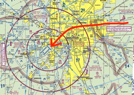
Fast forward to a couple of longer-than-expected fuel stops and there we were following Route 70 from Dayton, OH to Indianapolis, IN. The headlights and taillights on the vehicles made following the long stretch of road with really only one set of bends very easy. But as we approached Indianapolis the lights of the roads and the city and those of the airport we’re seeming to blend together. Yes it was late, but I wasn’t fatigued thanks to some napping I had gotten in during the trip, having another pilot to switch off with made the flight a breeze. Regardless it was a real challenge to find the airport. Based on the chart and my moving map I knew exactly where it should have been when I looked out the window, but the lights I was seeing didn’t seem to make sense. Based on the GPS I was able to line up for final and was cleared to land many miles out which prompted me to alert the controller that I was unfamiliar and I hadn’t “picked up” the airport just yet.
It was right at that second I realized I was higher than I probably should have been and I was looking beyond where the airport would be, so I asked the controller, “Could you light it up, turn everything up as high as it will go”.
You’d have thought the sun came up at that second. Maybe it was just my perspective but it looked like every airport light ultimately went to atomic level and I was in need of sunscreen to prevent a burn…
At that second I picked up the runway and yes I was high, very high. The power went to idle, flap speed was attained, full flaps and a slip as we approached all led to a nice smooth touchdown and roll out. The runway provided more than enough room and I dissipated enough energy with the slip to end up making an intersection turn off that allowed me to taxi right into the FBO.
The rest of the trip was uneventful, we ended up landing in St. Louis in the early morning hours, around 0230, naturally we slept late into the next morning. The one fun part of the final leg was a controller who could hear the 152 that was trailing us but the 152 could not hear them. The controller asked if I would relay the Class B clearance so that the pilot of the 152 could repeat it back. As long as the controller said it and the pilot repeated it back the clearance would be valid. Naturally, I enjoyed issuing the clearance for the 152 into the St. Louis Class Bravo airspace…
The real takeaway from this story is that when you need help and/or assistance don’t be afraid to ask for it. In this case the ask was fairly simple, “light it up” the actual act of the change in lighting intensity helped me identify the airport and the extreme brightness provided excellent situational awareness. This request took me some time to come up with though, I’m not sure why the thought popped into my mind, but I’m glad the idea came to me when it did… So don’t be afraid to think outside of the box and ask for assistance when you need it.
-Fly Safe, @MTElia1B9
