
Howling winds, crashing waves, blinding whiteouts, feet of snow. Currently, this Tuesday the 14th, New England is being pummeled with conditions like these. For a student pilot, or even an airline pilot, it will be a pretty easy go/no go decision during the heart of the storm. But, let’s take a closer look at the science of today’s weather and see what we can learn… What is a Nor’easter exactly, and how could something pack such a heavy punch, even in Winter?
A Nor’easter is a low pressure system. From ground school, we know that low pressure systems are known as “Cyclones” and in the Northern Hemisphere, rotate inward and counterclockwise. Wind Direction (not location) of the storm, is how it gets its name -When strong winds coming from a Northeasterly direction hit a particular area.
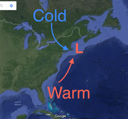
Nor’easters can form anywhere along the East Coast from Georgia to Maine. They rapidly intensify in Northerly locations, because of massive air temperature and density differences. Canada is home to cold, dry, dense air. The Gulf of Mexico, and Caribbean latitudes have warm, humid, much less dense air than Canada. When a low pressure system finds its way to the Eastern shore of the US in winter months, it has the perfect ingredients to fuel a massive temperature/density difference.
Because of the counterclockwise rotation of a Low pressure system, cold, dense Canadian air is pulled into the center of the Low. Warm, humid, less dense air from tropical latitudes is also pulled into the center of the Low.
Now, constricted into a small area, is an absolutely massive temperature and density difference. The two air masses will try and balance themselves out. However, because Warm and Cold are so close together, they don’t have much room to equalize, and create very high, localized wind.
Due to the Coriolis effect, the wind will turn counterclockwise. If the Low pressure system is off the East coast, the wind will travel over warm ocean water, and increase in temperature and moisture.
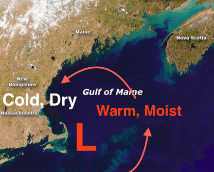
When warm moist air continues its cycle around the center of the low, it eventually runs into cooler, dryer air over land, and precipitates rain or snow. In today’s case, lots of snow. Notice, when air from the ocean hits the coastline, the direction is Northeasterly.
If we were to look at a barometer when these conditions happen, we would see a rapid drop in atmospheric pressure in a short amount of time. This phenomenon has been recently termed “Bombogenesis” Bomb-coming from the rapid drop in atmospheric pressure, and Genesis- the beginning of a cyclone. For a system to be classified Bombogenesis-it has to have a drop of 24 millibars in 24 hours.
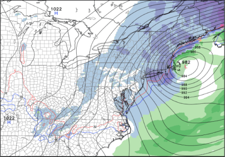
Image courtesy: NCEP GFS
Here is a surface analysis chart showing isobars. Notice how steep the pressure gradient is over a very short distance. It is essentially an atmospheric sinkhole.

Image courtesy: NOAA
Sometimes, Nor’easters can become so unstable, they develop an “eye of the storm” in the lowest pressure region of the system. This is very similar to a hurricane’s eye. However, the formation of a hurricane and Nor’easter are different. Hurricanes are fueled by the release of latent heat of condensation they absorb over warm waters. Nor’easters are also fed by latent heat, but their primary source of fuel is the contrasting temperature/density difference of the atmosphere. When Nor’easters get powerful enough, they can become named. For example, 2013’s February storm “Nemo” which produced blizzard conditions and bombed out with a pressure of just 968 mb or 28.65” hg. with max winds of 102 MPH. Typically, Nor’easters will be most intense between October and April, when there is a large temperature difference between polar and tropical latitudes.
Stay warm!
-Fly Safe, WSmithEWB CFI/CFII

Nice to refresh of how the storm is born! 😉